Mapping the Unseen: How Bedrock Ocean's Robots are Revolutionizing Seafloor Surveys
The Earth's oceans, covering over 70% of the planet's surface, remain one of its most mysterious frontiers. Despite their immense size and critical importance to global ecosystems, climate, and commerce, our understanding of the deep seabed lags significantly behind our knowledge of celestial bodies like the moon. This disparity isn't due to a lack of interest, but rather the formidable challenges posed by the underwater environment – crushing pressures, impenetrable darkness, and the sheer difficulty of deploying and operating technology far below the surface. For decades, mapping the ocean floor has been a slow, expensive, and often environmentally disruptive process, relying primarily on large, crewed vessels.
However, a new wave of innovation is emerging, driven by advancements in robotics and artificial intelligence. A number of startups are now competing to develop more efficient and accessible methods for exploring and mapping the ocean depths. Among these pioneers, Bedrock Ocean has recently garnered significant attention, announcing the closure of a $25 million Series A-2 funding round. This investment, led by Primary and Northzone, with participation from Autopilot, Costanoa Ventures, Harmony Partners, Katapult, and Mana Ventures, underscores growing confidence in Bedrock's approach to tackling the complex problem of seafloor mapping.
The Critical Need for Detailed Seafloor Maps
Why is mapping the ocean floor so crucial? Beyond scientific curiosity, detailed maps of the seabed are essential for a wide range of human activities and environmental stewardship. Industries rely on accurate bathymetry (water depth) and seafloor composition data for planning and executing operations. For instance:
- Offshore Energy: The burgeoning offshore wind industry requires precise maps to identify suitable locations for turbine foundations, plan cable routes, and monitor seabed changes. The oil and gas sector needs detailed surveys for pipeline installation, platform placement, and reservoir exploration.
- Infrastructure Development: Laying underwater cables for telecommunications, planning tunnels, or constructing ports and other coastal infrastructure all depend on understanding the underwater terrain.
- Resource Management: Sustainable fisheries management, mineral exploration, and the identification of potential deep-sea mining sites require comprehensive seafloor data.
- Environmental Monitoring and Conservation: Mapping helps scientists understand marine habitats, track pollution, study geological processes like underwater landslides and volcanic activity, and assess the impact of climate change on ocean ecosystems.
- Defense and Security: Navies require detailed maps for navigation, submarine operations, mine detection, and strategic planning.
- Scientific Research: Oceanographers, geologists, and marine biologists use seafloor maps to study everything from tectonic plate movements to the distribution of deep-sea species.
Despite this critical need, vast areas of the ocean floor remain poorly mapped, often relying on outdated or low-resolution data. The challenges of the deep sea have historically made comprehensive surveying prohibitively expensive and time-consuming.
Traditional Ocean Mapping: A Costly and Cumbersome Endeavor
Historically, seafloor mapping has been the domain of large, specialized survey ships. These vessels are equipped with powerful sonar systems that emit acoustic pulses down to the seabed and measure the time it takes for the echoes to return. By analyzing these echoes, scientists and surveyors can determine water depth and infer characteristics of the seafloor material.
While effective, this traditional method comes with significant drawbacks:
- High Operating Costs: Large ships require substantial amounts of fuel and large crews, making survey missions incredibly expensive.
- Slow Pace: Covering vast areas with ship-mounted sonar is a time-consuming process, limiting the frequency and scope of surveys.
- Environmental Impact: The powerful sonar pulses used by traditional survey ships can potentially disrupt marine life, particularly marine mammals that rely on sound for navigation and communication.
- Logistical Complexity: Deploying and managing large survey vessels requires extensive planning and coordination.
For years, the industry has sought alternatives that could provide comparable or better data more efficiently. As Brandon Mah, COO of Bedrock Ocean, noted to TechCrunch, the long-standing goal has been to find a way to "replace traditional ships" for these tasks.
Bedrock Ocean's Autonomous Approach
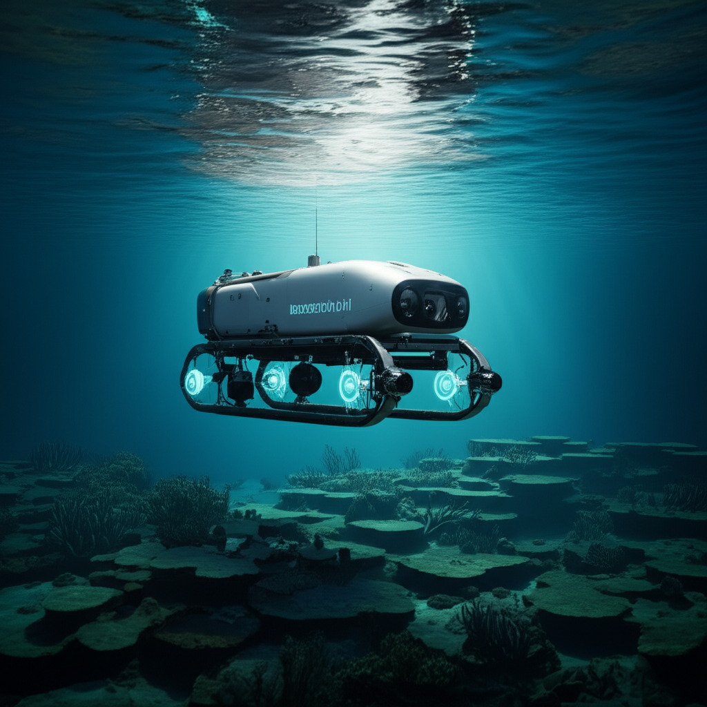
Bedrock Ocean is addressing these challenges head-on with its fleet of autonomous underwater vehicles (AUVs). Unlike traditional methods, Bedrock's approach centers around deploying smaller, intelligent robots that can operate independently beneath the surface, significantly reducing the reliance on large, expensive ships for the mapping itself.
The company designs and builds its own AUVs, which are equipped with advanced sensors, including sonar and magnetic sensors. These vehicles are powered by lithium-ion batteries, allowing them to operate for extended missions, reportedly up to 12 hours on a single charge. The AUVs navigate autonomously, following pre-programmed survey paths to systematically map the designated area of the seafloor.
While the AUVs operate independently underwater, they are still launched and recovered from a surface vessel. However, the surface ship's role is primarily support and data relay, not the active, energy-intensive surveying itself. This operational model allows for greater flexibility and efficiency. According to Mah, two of Bedrock's AUVs can cover the same area as a single traditional mapping ship, and a relatively modest 40-foot ship could potentially carry and deploy 10 to 12 of these AUVs, dramatically increasing the potential coverage area per mission.
Technology Under the Waves
Bedrock's AUVs are sophisticated pieces of engineering. Their core mapping capabilities rely on:
- Sonar: Using less powerful sonar than traditional ship-based systems, the AUVs operate closer to the seafloor (typically five to 10 meters above it). This proximity allows them to achieve high-resolution data with lower power output. Mah highlighted that Bedrock's sonar operates at frequencies outside the audible range for marine mammals, and its close proximity to the seabed means animals are less likely to be in the direct path of the acoustic beam, reducing potential environmental impact compared to powerful, downward-facing ship sonar.
- Magnetic Sensors: In addition to sonar, the AUVs are equipped with magnetic sensors. These can detect variations in the Earth's magnetic field caused by different geological formations or submerged objects, providing another layer of data about the seafloor composition and potential targets of interest.
- Inertial Navigation: Once submerged, AUVs lose access to GPS signals. Bedrock's AUVs rely on inertial navigation systems (INS) to track their position underwater. INS uses accelerometers and gyroscopes to estimate position based on movement from a known starting point. While INS is highly accurate over short periods, errors can accumulate over time without external position updates.
- Data Handling: The AUVs process some data onboard and store it locally. When they surface, they can transmit the collected data to the support ship via Wi-Fi. The ship, equipped with a Starlink antenna, can then beam this information to the cloud, allowing observers on shore or on the ship to monitor the survey progress and data quality in near real-time. This capability is a significant advantage, enabling rapid assessment and the ability to investigate interesting findings quickly.
Advantages Over Traditional Methods
Bedrock's autonomous approach offers several compelling advantages:
- Cost Reduction: AUVs are significantly less expensive to build and operate than large survey ships. Mah stated that Bedrock's AUVs cost less than $1 million each, a fraction of the cost of a specialized vessel. Lower fuel consumption and reduced crew requirements further decrease operational expenses.
- Increased Speed and Efficiency: Deploying multiple AUVs from a single vessel allows for faster coverage of large areas. The ability to process and transmit data quickly also speeds up the overall survey workflow.
- Reduced Environmental Impact: The use of less powerful, higher-frequency sonar deployed closer to the seabed minimizes potential disturbance to marine life.
- Improved Data Accessibility: Real-time data transmission to the cloud allows stakeholders to access and analyze information much faster than waiting for a ship to return to port.
Bedrock has also developed its own software suite, not only for operating the AUVs but also for processing and managing the vast amounts of data they collect. This integrated hardware and software approach allows the company to control the entire workflow and optimize performance.
Accuracy and Applications
One key difference between Bedrock's AUV-based surveys and traditional ship-based surveys lies in positioning accuracy. Because AUVs rely on inertial navigation underwater, they typically achieve positioning accuracy of one to two meters. This is slightly less precise than the sub-meter accuracy that can be achieved with some ship-based systems that use acoustic positioning relative to the surface vessel, which can be precisely tracked via GPS.
However, Bedrock argues that sub-meter accuracy is not always necessary for every application. While initial site surveys for critical infrastructure like offshore wind foundations might require the highest precision, many subsequent or broader surveys can effectively utilize data with one to two-meter accuracy. For example, monitoring seabed changes, mapping cable routes, or conducting environmental assessments might not require sub-meter precision. The trade-off in accuracy is often offset by the significant gains in speed, cost-effectiveness, and environmental friendliness.
The market response suggests this trade-off is acceptable, even desirable, for many clients. Bedrock has already been conducting paid survey work for several quarters across various sectors:
- Offshore Wind: Providing surveys for site assessment, cable routing, and foundation planning.
- Oil and Gas: Supporting infrastructure planning and monitoring.
- Environmental Assessments: Mapping habitats and monitoring seabed conditions for ecological studies.
- Defense: The speed and data accessibility of Bedrock's system have attracted the attention of the U.S. Navy, which is interested in faster methods for understanding underwater environments for strategic purposes. Mah noted that demonstrating the system's capabilities to the Navy left them "kind of blown away."
The ability to quickly assess data quality and identify potential targets in near real-time is a major selling point for Bedrock, allowing clients to make faster decisions and optimize their operations.
The Funding Landscape for Ocean Technology
Bedrock's successful Series A-2 funding round highlights increasing investor interest in the ocean technology sector, particularly solutions that address critical needs like mapping, monitoring, and sustainable resource development. The $25 million infusion provides Bedrock with substantial capital to scale its operations, expand its fleet of AUVs, and further develop its software platform.
The investors involved, including Primary and Northzone, are betting on Bedrock's technology to capture a significant share of the growing market for seafloor surveying. Demand is being driven by global trends such as the expansion of offshore renewable energy, the need for better environmental data in the face of climate change, and ongoing requirements from traditional industries like oil and gas, as well as defense.
The investment also reflects a broader trend towards automation and robotics in challenging environments. Just as autonomous vehicles are being developed for land and air, AUVs are becoming increasingly capable and reliable for underwater tasks, opening up new possibilities for exploring and utilizing the ocean.
Bedrock is not alone in this space; other startups are also working on innovative ocean mapping solutions. However, Bedrock's focus on building its own integrated hardware and software system, combined with its early traction in securing paid contracts across multiple industries, positions it as a strong contender in this evolving market. The funding will be critical for moving from the development and pilot phase to widespread commercial deployment.
The Future of Seafloor Mapping
The deep ocean remains one of the least explored parts of our planet. High-resolution maps are fundamental to unlocking its secrets and managing its resources responsibly. Technologies like those developed by Bedrock Ocean are essential for accelerating this process.
Faster, cheaper, and more environmentally conscious mapping capabilities will have far-reaching impacts. They can support the rapid expansion of offshore renewable energy, provide crucial data for understanding and mitigating the effects of climate change, improve maritime safety and security, and enable new scientific discoveries.
As AUV technology continues to advance, we can expect these robots to become even more sophisticated, capable of longer missions, operating in deeper waters, and collecting an even wider array of data. The integration of artificial intelligence will likely play a larger role in onboard data processing and autonomous decision-making, further enhancing efficiency.
Bedrock Ocean's recent funding round is more than just a financial milestone for a single company; it's a signal of increasing momentum in the field of marine robotics and ocean technology. It underscores the growing recognition that understanding the ocean floor is not just a scientific pursuit, but a critical requirement for sustainable development, economic growth, and national security in the 21st century.
With this new capital, Bedrock is well-positioned to play a key role in finally lifting the veil on the vast, unseen world beneath the waves, providing the detailed maps necessary to navigate, utilize, and protect our planet's largest ecosystem. The race to map the ocean floor is accelerating, and autonomous systems like Bedrock's AUVs are leading the charge.